


Sunday, 13 April 2014
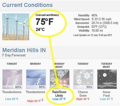
Or do I have to wait until Tuesday?
Posted by: Old Grouch in
Dear Diary...
at
23:11:12 GMT
| Comments (1)
| Add Comment
Post contains 18 words, total size 1 kb.
Friday, 10 January 2014
Per the NWS, about this much:
")
Posted by: Old Grouch in
Dear Diary...
at
17:02:25 GMT
| No Comments
| Add Comment
Post contains 40 words, total size 1 kb.
Sunday, 05 January 2014
 Sunday 5 Jan 2014 from NWS Winter Weather page http://www.hpc.ncep.noaa.gov/wwd/winter_wx.shtml accessed 1pes 5 Jan 2014.")
Yep, that’s 40% probability of 12 inches or more, right there east of Indianapolis.
UPDATE:
Posted by: Old Grouch in
Dear Diary...
at
19:35:26 GMT
| No Comments
| Add Comment
Post contains 33 words, total size 2 kb.
Sunday, 08 December 2013
Just a ‘‘slight chance’’ for us in Indy, but look out! east and south:
Tonight and tomorrow:

Monday night and Tuesday:

Posted by: Old Grouch in
Dear Diary...
at
21:56:15 GMT
| No Comments
| Add Comment
Post contains 26 words, total size 2 kb.
Friday, 06 December 2013
Two inches already on the ground at bedtime...
 Snowfall Accumulation Probabilities • consolidated from http://www.hpc.ncep.noaa.gov/wwd/winter_wx.shtml • as updated 2011Z, Thursday 5 Dec 2013.")
Yes, that’s a 10% chance of 12" or more by the time it’s over... right there in the center!
LATER: Came the dawn: Not much additional accumulation here, but the forecasters warn of a possible 5" more this afternoon.
From the archives:
Posted by: Old Grouch in
Dear Diary...
at
06:07:33 GMT
| No Comments
| Add Comment
Post contains 63 words, total size 1 kb.
Tuesday, 12 November 2013
First snow of the season...
Posted by: Old Grouch in
Dear Diary...
at
19:06:05 GMT
| No Comments
| Add Comment
Post contains 13 words, total size 1 kb.
Sunday, 25 August 2013

Posted by: Old Grouch in
Dear Diary...
at
18:41:49 GMT
| Comments (2)
| Add Comment
Post contains 2 words, total size 1 kb.
Monday, 25 March 2013
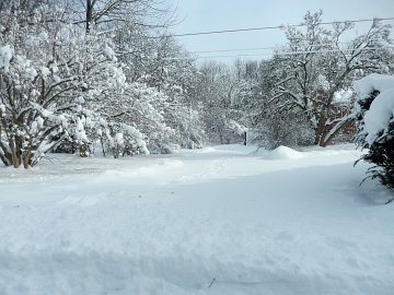
...and we’re dealing with it. (Some better than others!)
Took me 15 minutes to get the car broomed off (Someday I’ve GOT to get the garage cleaned out!), and an additional half hour to clear the drive sufficiently to make it up the hill to the street. Streets, by the way, were amazingly clean, especially compared to the typical ‘‘snow removal[1]’’ the city usually provides.
Tam and Roberta have pictures.
LATER:

Note that 15" blip over near Springfield!
-----
Posted by: Old Grouch in
Dear Diary...
at
17:53:58 GMT
| No Comments
| Add Comment
Post contains 88 words, total size 2 kb.
Sunday, 24 March 2013
Late news from the Rialto:
URGENT - WINTER WEATHER MESSAGE
NATIONAL WEATHER SERVICE INDIANAPOLIS IN
1003 AM EDT SUN MAR 24 2013
SIGNIFICANT LATE SEASON WINTER STORM TO IMPACT CENTRAL INDIANA
A STRENGTHENING LOW PRESSURE WILL LIFT NORTHEAST ACROSS NORTHEASTERN KENTUCKY TONIGHT IN RESPONSE TO A STRONG UPPER LOW PRESSURE SYSTEM MOVING EAST FROM THE MIDDLE MISSISSIPPI VALLEY. THIS WILL PRODUCE STRONG LIFT THAT WILL INTERACT WITH DEEP MOISTURE AND RESULT IN A SIGNIFICANT SNOW STORM FOR THE REGION. THE SNOW WILL CONTINUE THROUGH MONDAY WITH THE HEAVIEST SNOW EXPECTED LATE THIS AFTERNOON AND TONIGHT. THE SNOW WILL MIX WITH RAIN AND POSSIBLY SLEET OVER SOUTHERN PORTIONS OF CENTRAL INDIANA DURING THE LATE MORNING AND AFTERNOON BEFORE CHANGING TO ALL SNOW THERE BY EARLY EVENING.
SNOW ACCUMULATIONS OF 6 TO 10 INCHES WITH LOCALLY HIGHER AMOUNTS ARE EXPECTED ACROSS MUCH OF CENTRAL INDIANA THROUGH MONDAY MORNING. GUSTY NORTHEAST AND NORTH WINDS WILL ALSO CAUSE SOME BLOWING SNOW ESPECIALLY ALONG WEST TO EAST ORIENTED ROADWAYS.
...
• TIMING: LIGHT ACCUMULATIONS WILL BE POSSIBLE THROUGH MID AFTERNOON. SNOW WILL INCREASE IN INTENSITY LATE THIS AFTERNOON AND TONIGHT, BECOMING HEAVY AT TIMES. WHILE SNOW IS EXPECTED TO LIGHTEN MONDAY MORNING, IT IS EXPECTED TO CONTINUE WITH THE POTENTIAL FOR ADDITIONAL LIGHT ACCUMULATIONS.
...and here’s the map:
 Snowfall Accumulation Probabilities consolidated from: http://www.hpc.ncep.noaa.gov/wwd/winter_wx.shtml as updated 0739Z, March 24, 2013")
We had a dusting this morning, but it didn’t stick. Right now (1:50 EDT) there’s nothing on the ground, nothing coming down, and temperature is just above freezing. Will it Really Happen? Guess we’ll find out, one way or t’other...
Posted by: Old Grouch in
Dear Diary...
at
18:00:43 GMT
| No Comments
| Add Comment
Post contains 259 words, total size 3 kb.
Saturday, 23 March 2013
NWS:
URGENT - WINTER WEATHER MESSAGE
NATIONAL WEATHER SERVICE INDIANAPOLIS IN
1048 AM EDT SAT MAR 23 2013
WINTER STORM WATCH IN EFFECT FROM 8 AM SUNDAY THROUGH 12 PM
MONDAY
STRENGTHENING LOW PRESSURE WILL LIFT NORTHEAST FROM THE TENNESSEE VALLEY TO THE OHIO VALLEY SUNDAY AND SUNDAY NIGHT WHICH IS EXPECTED TO RESULT IN A SIGNIFICANT SNOW STORM FOR THE REGION. THE SNOW WILL START OVERNIGHT TONIGHT AND CONTINUE THROUGH MONDAY WITH THE HEAVIEST SNOW EXPECTED LATE SUNDAY AFTERNOON AND NIGHT. THE SNOW MAY MIX WITH RAIN OVER SOUTHERN PORTIONS OF CENTRAL INDIANA THROUGH LATE SUNDAY AFTERNOON BEFORE CHANGING TO ALL SNOW.
SNOW ACCUMULATIONS OF 5 TO 9 INCHES ARE EXPECTED ACROSS MUCH OF CENTRAL INDIANA THROUGH MONDAY MORNING, WITH LOWER AMOUNTS OF 3 TO 6 INCHES SOUTH OF A SULLIVAN TO BLOOMINGTON TO COLUMBUS LINE WHERE RAIN IS LIKELY TO MIX IN WITH THE SNOW ON SUNDAY.
On the map, it looks like this:
 Snowfall Probability Maps (consolidated from http://www.hpc.ncep.noaa.gov/wwd/winter_wx.shtml updated 0743Z, March 23, 2013)")
Don’t forget the beer, toilet paper, and cat litter!
Elsewhere:
Posted by: Old Grouch in
Dear Diary...
at
16:43:53 GMT
| No Comments
| Add Comment
Post contains 179 words, total size 3 kb.
52 queries taking 0.3179 seconds, 167 records returned.
Powered by Minx 1.1.6c-pink.


