


Saturday, 27 February 2010
National Weather Service:
There’s also an update to my previous post.RECORD EVENT REPORT...UPDATED
NATIONAL WEATHER SERVICE NEW YORK NY
217 AM EST SAT FEB 27 2010
...RECORD MONTHLY MAXIMUM SNOWFALL SET AT CENTRAL PARK...WHICH IS
ALSO THE RECORD MAXIMUM SNOWFALL FOR FEBRUARY AT CENTRAL PARK NY...
...RECORD DAILY MAXIMUM SNOWFALL SET AT CENTRAL PARK NY...
AN ALL TIME MONTHLY RECORD SNOWFALL OF 36.9 INCHES WAS SET AT
CENTRAL PARK NY. THIS BREAKS THE ALL TIME SNOWIEST MONTH RECORD FOR
CENTRAL PARK. THE OLD RECORD WAS 30.5 INCHES SET BACK IN MARCH 1896.
THIS 36.9 INCHES OF SNOW AT CENTRAL PARK IN FEBRUARY ALSO BREAKS THE
OLD RECORD SNOWFALL IN FEBRUARY OF 27.9 INCHES SET IN 1934.
LASTLY...A RECORD DAILY SNOWFALL OF 11.5 INCHES WAS ALSO SET AT
CENTRAL PARK NY TODAY. THIS BREAKS THE OLD RECORD OF 8.4 SET IN 1991.
Posted by: Old Grouch in
Dear Diary...
at
22:44:00 GMT
| No Comments
| Add Comment
Post contains 148 words, total size 2 kb.
Thursday, 25 February 2010
For us in Indy, the prediction is an inch or so overnight, with more to the north. But it looks like the east may get slammed- again.
Predicted snowfall map for tonight and tomorrow:[1]

AccuWeather’s Alex Sosnowski (HT: Bill Quick):
The same storm that brought a gentle snowfall across Texas on Tuesday will reach the Northeast in the form of an atmospheric monster with damaging winds, blinding snow, torrential rain, huge waves and flooding...They’re reporting 10-20" already on the ground in eastern New York State. The National Weather Service expects the second low to pull in warmer air up into the Hudson Valley, which would make Thursday’s precipitation in that area (around Albany) fall mostly as rain. But for eastern Pennsylvania they’re still talking snow: 6-14 inches worth.
Wind
Wind gusts can reach 70 mph in some areas, just shy of hurricane force. Many locations in the mid-Atlantic and New England will endure gusts topping 50 mph at some point Thursday to Friday...
Tides
The powerful winds will lead to coastal flooding in New England, while causing disruptive blowout tides and very low water levels in some seaports the mid-Atlantic from New Jersey to the Carolinas.
Snowfall
Snowfall from the storm will accumulate 1 to 2 feet from western Maine to northern Vermont and over much of the Mohawk and Hudson valleys in New York state as well as the Catskills and Poconos. Albany, Binghamton, Rochester and Scranton fall within this zone.
A broad area of 6- to 12-inch snowfall will fall from northern New Brunswick to central New Jersey, much of Pennsylvania, northeastern Ohio and southern Ontario. New York City, Buffalo, Montreal, Ottawa, Toronto and part of the Philadelphia area lie in this area.
Thursday night and Friday (note these are additional accumulations):

If those temperatures don’t get above freezing, Friday could be interesting.
UPDATE (Saturday 100227 18:25, links via IP):
Associated Press: More than a million in the dark on East Coast
Friday’s storm made February the snowiest month ever for New Brunswick, N.J.; it has gotten 37 inches so far. This had already been the snowiest winter for Philadelphia and Atlantic City, N.J., before the latest storm dropped another 4 to 5 inches by midmorning Friday.The Weather Channel’s James Wilson:
In New York City at Central Park, there was 20.9 inches reported with this amazing storm. This was the 4th largest snowstorm in their long history that goes all the way back to 1869.
-----
Posted by: Old Grouch in
Dear Diary...
at
00:04:44 GMT
| No Comments
| Add Comment
Post contains 425 words, total size 5 kb.
Sunday, 14 February 2010
Probabilities for 24 hours beginning at 7pm Sunday:
Radar already shows light snow falling in Johnson County and points south. Was thinking about running down to Greenwood this evening for Chinese; maybe I’ll skip it.
Posted by: Old Grouch in
Dear Diary...
at
23:53:45 GMT
| No Comments
| Add Comment
Post contains 68 words, total size 1 kb.
Monday, 08 February 2010
Predicted snowfall map through the overnight:

Tuesday:

Wednesday:

As of noon, they’re saying “five to eight inches†for central Indiana. Lovely.
Roberta has pix from Saturday, promises to soldier on.
Posted by: Old Grouch in
Dear Diary...
at
19:04:55 GMT
| No Comments
| Add Comment
Post contains 42 words, total size 2 kb.
Saturday, 06 February 2010
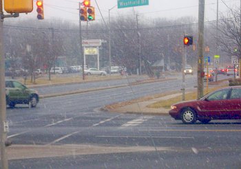
They’re saying we got 6 inches accumulation, which matched my driveway. Could have been more, but I’d guess a fair amount must have melted early on. Last night things were quite sloppy; was the kind of snow we usually get in late March, not early February.
Amazingly, the city has done a pretty good job of clearing the major streets. Here’s yesterday’s intersection- 24 hours later.
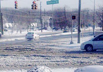
Yes, that’s sunshine.
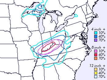
Meanwhile, the fun continues to the east. The numbers are additional accumulations predicted for today.

Oh, and the NWS has us slated for another 4 inches or so (40% probability) on Monday.
Everybody’s telling weather stories over at Tam’s.
MORE: Washington D.C. pictures (via SDB)
Posted by: Old Grouch in
Dear Diary...
at
16:53:39 GMT
| No Comments
| Add Comment
Post contains 126 words, total size 3 kb.
Friday, 05 February 2010

Shovels ready?
Posted by: Old Grouch in
Dear Diary...
at
16:34:43 GMT
| No Comments
| Add Comment
Post contains 42 words, total size 1 kb.
50 queries taking 0.0565 seconds, 155 records returned.
Powered by Minx 1.1.6c-pink.


