


Tuesday, 20 April 2010
Blog•Meet Whatzit
For context and background, read Looking East (and the comments), then Roberta’s April BlogMeet report.
Long story short: Roberta X’s second tower tour post included this long-distance photo of an example of our city’s industrial past...
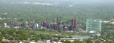
...and a request for help in identifying it. In her post she helpfully linked Google’s aerial view of the site.
This long-time Indy resident recognized the plant immediately (answer in the comments), but when I looked at the aerial view I was amused to notice another item in Indianapolis lore. Thinking it might be fun to see how quickly people could identify it or discover its purpose, I printed off some copies and took them to Sunday’s BlogMeet. It took less than five minutes for our astute panel to figure it out. How about you?
Here’s the image of (most) of the site.
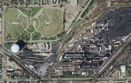
What’s that very different space in the upper left-hand corner?
Closer up:

Of course, you could probably go searching for the answer, but IMO it’s more fun to figure out what it is from the image alone.
No clue? You’ll find some hints below the break. Answer coming tomorrow.
The top of the two aerial images is north, not that it makes any difference. Roberta’s photo is taken from the west-northwest, so a north-south line would run more or less from the lower left to the upper right.
Hint #1:
By the way, the size of objects on the screen is almost exactly the size they were on the picture I printed, so you’re not working at a disadvantage.
Hint #2:
Hint #3:
Got it?
Comments are disabled.
Post is locked.
For context and background, read Looking East (and the comments), then Roberta’s April BlogMeet report.
Long story short: Roberta X’s second tower tour post included this long-distance photo of an example of our city’s industrial past...
...and a request for help in identifying it. In her post she helpfully linked Google’s aerial view of the site.
This long-time Indy resident recognized the plant immediately (answer in the comments), but when I looked at the aerial view I was amused to notice another item in Indianapolis lore. Thinking it might be fun to see how quickly people could identify it or discover its purpose, I printed off some copies and took them to Sunday’s BlogMeet. It took less than five minutes for our astute panel to figure it out. How about you?
Here’s the image of (most) of the site.
What’s that very different space in the upper left-hand corner?
Closer up:
Of course, you could probably go searching for the answer, but IMO it’s more fun to figure out what it is from the image alone.
No clue? You’ll find some hints below the break. Answer coming tomorrow.
The top of the two aerial images is north, not that it makes any difference. Roberta’s photo is taken from the west-northwest, so a north-south line would run more or less from the lower left to the upper right.
Hint #1:
By the way, the size of objects on the screen is almost exactly the size they were on the picture I printed, so you’re not working at a disadvantage.
Hint #2:
Hint #3:
Got it?
Posted by: Old Grouch in
In Passing
at
19:17:18 GMT
| Comments (3)
| Add Comment
Post contains 234 words, total size 4 kb.
1
Your bottom photo seems to be a vertical view of two old drive-ins. We have a few of those left here in KC At least I think a couple are still open.
Posted by: Crucis at 04/20/10 19:19:38 (L4D3z)
2
Sure does look like a dead drive-in theater.
Posted by: Rob K at 04/21/10 01:12:38 (SZQ1s)
3
The only time I've ever spent in Indianapolis was when I drove through it once on my move west, but those sure look like closed drive-in theaters to me.
Posted by: JohnW at 04/21/10 17:30:25 (BRC/F)
71kb generated in CPU 0.0435, elapsed 0.1486 seconds.
53 queries taking 0.1282 seconds, 211 records returned.
Powered by Minx 1.1.6c-pink.
53 queries taking 0.1282 seconds, 211 records returned.
Powered by Minx 1.1.6c-pink.


